
#326: India's 'new' coastline size
Extra territory or better measure?

Trying new form of formatting here, let me know if this is easier to read:
How India ‘added’ more than 3,500 km to its coastline, 7 new islands
India’s coastline length increased by 3,582 km: from 7,516 km (1970s estimate) to 11,098 km now (approx. 48% rise).
Increase due to better measurement techniques, not territorial expansion.
Total number of islands revised to 1,389 after data reconciliation; includes 1,298 offshore islands and 91 inshore islands.

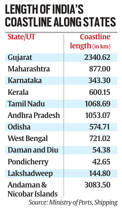
Longer Coastline
Earlier measurement scale: 1:45,00,000 (lower resolution).
Latest measurement scale: 1:2,50,000 (higher resolution, captures bends, curves, finer details).
High-res data and advanced software replaced manual estimates.
Inclusion of previously omitted offshore islands contributed to increased length.
The Coastline Paradox
Coastline length depends on measurement scale: higher resolution means longer apparent length.
True coastline length is impossible to define precisely due to irregularities.
Similar paradox applies to river lengths and mountain paths (irregular, scale-dependent).
India now mandates coastline measurement every 10 years for accuracy.
Additional Islands
No territorial addition, but revised counts through precise data and standardized classifications.
2016 survey by Surveyor General listed 1,382 offshore islands.
Reconciliation exercise fixed ambiguities; final total: 1,389 islands (excludes river islands in Assam, West Bengal).
Implications of Changes
New numbers aid better understanding of India’s territorial boundaries.
Administrative, developmental, security implications:
➤ Coastal Regulation Zones (CRZ) affected.
➤ Climate change resilience planning impacted.
➤ Tourism, infrastructure development strategies likely to evolve.